Hatfield and Reading Turnpike
This is a short story about one local turnpike. At one time there were three turnpikes around Henley; one to Hurley and Maidenhead, one to Dorchester and Oxford and one, the subject of this article, which went through Henley from Hatfield to Reading.
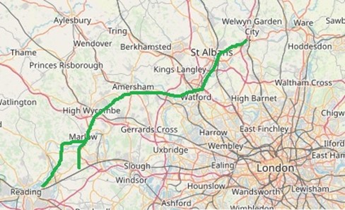
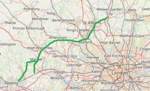
The route of the Hatfield Reading Turnpike
Where did this start? In the 16c, an Act of Parliament made parishes responsible for the upkeep of highways within their boundaries. This system was sufficient to maintain the local roads in many rural parishes, but where parishes had major highways passing through, it proved inadequate. The vehicles that damaged the roads were from other parishes, especially major stagecoach routes. So parish residents did not benefit nor had the necessary resources. As a result, some major highways became quagmires barely passable in winter.
In the early 18c, to reduce this burden on parishes, the first turnpike trusts were set up, each by Act of Parliament. These gave powers locally to collect road tolls for maintaining the major highways. By the 1830s, over 1,000 trusts administered around 30,000 miles of turnpike road in England & Wales, taking tolls at almost 8,000 toll-gates.
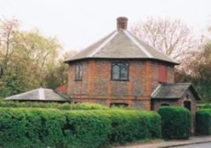
Toll House in Tidmarsh near Pangbourne
The term turnpike had originated from the military practice of placing a pikestaff across a road to block and control passage. Upon payment of the toll, the pike would be “turned” to one side to allow travellers through.
The new turnpikes were administered directly by the local justices of the peace. The trustees could erect gates as they saw fit, demand labour or a cash equivalent, and appoint surveyors and collectors. In return, they repaired the road and erected mileposts. The expectation was that the trust would borrow the money to repair the road and repay that debt over time with the road then reverting to the parishes. In reality, the initial debt was rarely paid off and the trusts were renewed as needed.
‘Gout Track’
One of the less likely routes set up was the ‘Hatfield and Reading Turnpike’, nicknamed the ‘Gout Track’. It was created in the 1760s to provide a route that connected the Great North Road (the modern A1) with the Holyhead Road (A5) and the Bath Road (A4). By 1881 it was one of the last of the turnpikes to have its tolls removed.
It is said that the Marquis of Salisbury, who lived at Hatfield House, wanted a route to the Great West Road that avoided central London, giving onward access to the spa towns of Bath and Cheltenham where, as a sufferer of gout, he often took the waters. This would also spare him the discomfort and congestion of London’s cobbled streets. With the Earl of Essex, who suffered from a similar affliction, and others, they sponsored an Act of Parliament passed in 1757 for the building of a road from Hatfield to Reading. Then the Reading and Hatfield Turnpike Trust was set up by a further Act passed in 1768. The turnpike ran from Hatfield through St Albans, Watford, Rickmansworth, Agmondesham (now Amersham), High Wycombe and Marlow, thence splitting to access the Great West Road; one at Knowl Hill and the other at Reading, that through Henley-on-Thames; in all some 50 miles.
The Trust lasted until 1881 and was one of the last Turnpike Trusts operating in the country. Analysis of toll receipts shows that traffic was lighter than on the great trunk routes it was connected to. Nevertheless, it stimulated the local economies along its route in trades like farriers, foraging and inn keeping.
The end of the Turnpikes
Many turnpike trusts were wound up under General Acts of Parliament between 1873 and 1878. The transfer of resources and sale of assets to repay loans were supervised by the Local Government Board which acted as arbiter in the case of disputes. Toll-houses were sold, gates torn down and responsibility for the main roads passed to Highway Boards. Bond-holders were paid off with any residual funds, though some did not get a satisfactory return on their investment
Under the Highways Act of 1878 all ‘disturnpiked’ roads became “Main Roads” as did some ordinary highways. By the Local Government Act 1888 the entire maintenance of main roads was passed to County Councils.
Structure of Turnpike Acts
The powers granted to a turnpike trust were viewed with suspicion. In effect the trustees were given powers to charge for use of an existing resource, the highway. Unlike the later canals and railway builders they were not creating a new facility and so their rights were restricted. Powers were only granted for a specific length of time and the trusts were not expected to make a profit, merely raise and use sufficient money to improve and maintain the road. Each trust was empowered through an individual Act of Parliament that closely specified what the trustees were permitted to undertake to achieve their objectives. Most acts contained a long list of those who were exempt from tolls. Exemptions fell into a number of categories; e.g. local farmers going about their husbandry tasks, officials and the military on county or national business, religious observance, voting, those involved in road maintenance and then groups who had negotiated concessions to permit the particular Act to pass.
What is left today?
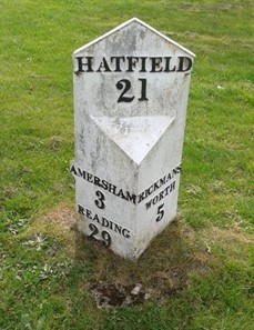
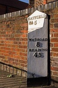
Most milestones and toll houses have long disappeared.
Hatfield Road
St Albans
Little Chalfont
Road classification by the newly formed Ministry of Transport in 1922, saw the route form parts of:
A414 – Hatfield to St Albans
A412 – St Albans – Watford – Rickmansworth
A404 – Rickmansworth – Amersham
A416 – Amersham – High Wycombe – Marlow – Knowl Hill
A32 – Marlow – Henley – Reading
Later, in 1935, the A404 was extended along the A416 section between Amersham and the A4 making it easier for those who wanted to use the route. The A32 section through Henley was renumbered the A4155 (later the A32 started south from Riseley but now it starts at Alton).
Administering such a long road through three counties through one body was problematic and so the 1829 Act specified three Districts. The First District ran from the north end of Caversham Bridge, being the boundary of the Borough of Reading, to the Three Horse Shoes in Henley and from Henley turnpike road near the Bell Inn to the SW corner of a barn on Thomas Wethered’s land entering Marlow. It then also covered the road from Marlow Bridge to the 31 mile-stone on the Maidenhead Turnpike. The second and third Districts covered the remainder of the turnpike to Hatfield.
Local relics
The book ‘Henley-on-Thames – A History’ by David C Whitehead refers to the turnpike. Elsewhere, there is recorded that on the road between Caversham and Henley there was a gate just south of Henley town and another further north of the town where the river turns east at Greenlands. A gate was placed on the main road at Marlow. Another gate in the village of Bisham controlled the road over Marlow Bridge towards the Maidenhead Road.
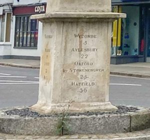
Obelisk in centre of Marlow, possible to be relocated
Nearby, it is understood that milestones can still be found at Chenies, Little Chalfont, Medmenham, Greenlands, and Burchett’s Green. Also, there is alleged to be the remains of a toll-house just south of Henley. All waiting for some local research!
Angus Ross for Henley Society
November 2023